History of Minnesota River Names
http://books.google.com/books?id=ho23eS5qjNgC&pg=PA145&lpg=PA145&dq=devils+track+river+get+its+name&source=bl&ots=j6lFZZaDEw&sig=D4TRdo21O35L4ht8qptcbUJjJng&hl=en&ei=QjO6TcPsKo26tge7p9ixAQ&sa=X&oi=book_result&ct=result&resnum=4&ved=0CC0Q6AEwAw#v=onepage&q&f=false
Thursday, April 28, 2011
Tuesday, April 26, 2011
Devils Track River Lines...
The rapids and lines on the Devils Track river are so often forgot year after year it seems. Mostly because people only paddle it once a year, and sometimes it doesn't flow every year.
Devil’s Track River Lines.
The run starts off with class II boogie water. You go through 2 narrow cliff walled canyons with class III drops. Next the canyon opens up and makes a large sweeping right hand curve and a horizon line with mist spraying up. Triple Drop rapid. You can take out on river left or river right. River left is to scout both drops and pick your line. River right take out is where you portage the rapid.
More walled in meandering class II following the portage Admiral falls. The river picks up pace and there is a distinct green water hump in the middle of the river signaling serpent slide rapid. Follow the flow and enjoy the ride.
The canyon walls open up with some long straight sections and easy paddling. After one of these long straight sections the river makes a left turn. This signals the 10 foot drop. The line is right of center down the green tongue.
Then you go under the superior hiking trail bridge. There is one more 10 foot drop. Run down the center. Be prepared to get sent towards the river right wall.
The river meanders through tall canyon walls until you come to the next horizon line. Portage down the middle. Eddy service is on river left or right. PDM is best scouted on river left. The line is to run 5 feet off the river right shore. Take a strong boof stroke and point the nose a little right. Land. Then take another boof stroke if you need too.
The easier take out which is starting to become the norm, is 100 yards downstream of PDM on river left before the canyon narrows up again. Hike straight up until you hit the superior hiking trail. Hike downstream maybe ½ mile until you see the walking bridge. Do not cross this bridge. The easy route down to the river is hike down through the woods on trail right before the bridge on trail right. Hike down and go towards that creek bed. Climb down onto the creek bed and follow to river. Very slippery and sharp on creek bed. Sometimes it’s best to just walk down the creek bed in water to get the most grip if it's icy on the sides of the creek.
After the Pitchfork portage, the river canyons up and meanders quite a bit until you see a big notch in the canyon and distinct horizon line. On a sunny day, It's probably the darkest spot on the river from lack of sunlight into the narrow gorge. There is a small eddy on river right if you want to scout Ski Jump and Up Against the Wall. Run ski jump right down the center. Bank right on the pillow. Try and get river right as much as possible for the most water under your boat. Left is ok too but scrappy. Ride into the big curler off river right wall at UAW. After Up Against the Wall, Get river left and run this drop river left into the hole at the bottom. And that's it for the big stuff. Enjoy the class II into Lake Superior.
Thursday, April 21, 2011
Illgen Falls - Baptism River
Here's a short clip of Scott White running Illgen Falls on the Baptism River. Illgen Falls is a a park and huck waterfall. It's as classic a waterfall as you will find anywhere in the world. The baptism river is located on the North Shore of Lake Superior, Minnesota USA.
Here is another North Shore video made by Minnesota Boater's Cliff Langley and Joel Decker
Here is another North Shore video made by Minnesota Boater's Cliff Langley and Joel Decker
Thursday, April 14, 2011
Lester River, Duluth Minnesota
Lester River located just north of the city limits of Duluth, MN, is the river that signals the start of the North Shore whitewater kayaking season. Here is a video from April, 9-10 2011
Monday, April 11, 2011
Southwestern Minnesota Boating
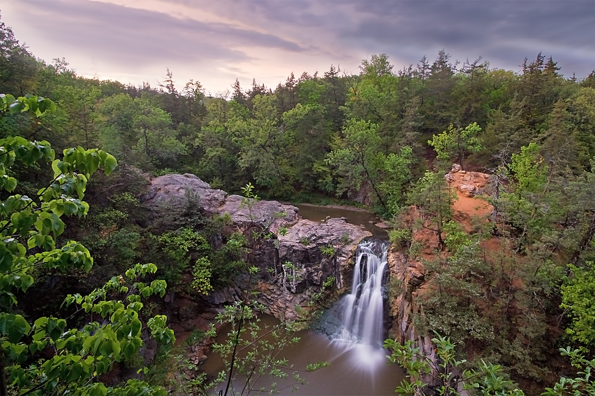
Ramsey Falls nicknamed Little Yellowstone
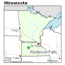
Located on the edge of the great plains, Redwood Falls, Minnesota is a Midwest whitewater destination during early spring runoff. Granite rock riverbeds and steep topography from the Minnesota River Valley create whitewater. It's 2 hours west of the Minneapolis and 1.5 hours from Mankato. Rivers in this area start running about 3 weeks before the more popular Minnesota whitewater destinations. They run about the same time as the Vermilion in Hastings usually around March 15th. And there is free camping at Beaver Creek Park. Camping is 5 miles north of Redwood Falls on county road 71, then go east on county road 2 for three miles and you see it after you cross the river on your right.
There are 3 primary whitewater rivers in the Redwood Falls area. The Redwood River, Ramsey Creek, and Beaver Creek. Plus a few other unexplored runs.
Here is a short video of Beaver Creek on April 2, 2011. Paddlers are Brian, Jade, Chris Baer, Scott White, and Justin Japs.
There is lots of information about the Redwood river and Beaver creek that can be found on americanwhitewater.org. However, Ramsey Creek and particularly Ramsey Falls (nicknamed Little Yellowstone), is fairly new to the whitewater world. The river consists of canyon wall class II whitewater and one big waterfall, Ramsey Falls.
Video 1 shows the visual water level on the first descent.
On March 19, 2011, Justin went back for another look at Little Yellostone. It was approximately double the flow of the first descent. A small rock outcrop was visual in the middle and two separate waterfalls on river right and left. It looked good to run.
On March 27, 2011, Scott White and Justin Japs returned to the falls with intentions to run it if water levels were the same or a little higher than the week before. The level was good and they both ran the falls. Video 2 shows Scott White's awesome descent.
So far what we have learned is this. This falls was measured with a throw rope on the 1st D at 32 vertical feet with an 60 degree 8 foot lead in. With higher flows, the cauldrom fills up a few more feet. There is no online gauge for Ramsey creek which makes it difficult to predict when it's running. At the base of the falls there is a small cave behind the river left that locals frequently swim into. One paddler has swam after running the falls. He flushed away from the base, and flushed out of the couldron with the rest of his gear. It was a non eventful swim and a typical yardsale of gear.The best safety is set up by repel from the river left cliff with throw ropes and with paddlers in the water within the cauldron at the base. The first descent of Ramsey Falls occured during the fall of the year after a major rain event. The ground was pretty dry prior. Redwood Falls got approximately 5 inches of rain over a 2 day period of time. The online gauge for the redwood maxed out somewhere around 7000cfs on or about September 27th, 2010. A week later, the Redwood gauge dropped to 2000cfs. This is when Ramsey Falls was run for the first time October 6th.
Ramsey falls is a high quality waterfall. It ran at good levels for 5 straight weeks during this years spring runoff. It's a straight forward waterfall and a relatively safe waterfall to run. The first picture above shows low water Ramsey falls and the exposed rock ledge throughout base of the falls except river left. This ledge is what made people afraid to run it for all these years, when in reality, when the flows are at runnable levels you so far out from any underwater ledges. To compare it to other Midwestern waterfalls, the cauldron setting and rolling lip is similar to Gorge falls, it's size is similar to Illgen falls, and the boof is like second drop on the east fork of the north shore Beaver river. Big soft aerated boils at the bottom provide great landing pads for flat landings. Ramsey Falls has been run 8 times to date, since it's discovery to kayakers in 2010. There is much more to learn.
Here is the Redwood River C.F.S. levels and dates from this spring.
s
Subscribe to:
Posts (Atom)